Google Maps will have a speed limit display feature on Android and iOS apps
After getting quite a lot of feedback from users, hopefully yes, hopefully, angry also has the final feature of speed limit protection on the roads finally brought to Maps by Google.
After receiving a lot of feedback from users, hope has, disappointment, anger also has the final speed warning feature on the roads finally brought to Google by Maps.Starting on January 21, Google will deploy this feature with a new update to the Google Maps application on iOS and Android devices.
- Leaked images of Android Q: There will be dark mode and more focused on privacy
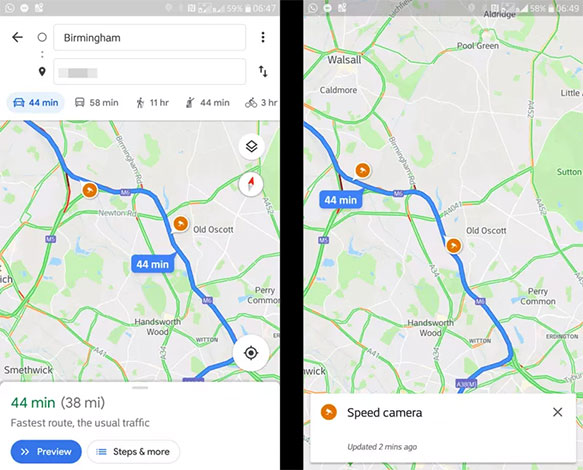
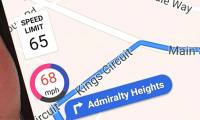
Accordingly, this new feature will appear as a speed-limited camera icon and show the speed allowed on the roads that users have, are and are about to pass.Speed icons are automatically displayed to help users adjust the 'accelerator' accordingly so as to avoid speeding errors on speed lines.In addition, Google Maps will also provide audible alerts for users whenever they reach the maximum speed threshold.It can be said that with this late but extremely useful addition, the traffic safety situation will definitely improve, thereby helping to limit unfortunate accidents due to not being able to control the speed.
Currently, Google says a full-featured update that includes speed limits and over-speed alerts will be released to users in Denmark, the United Kingdom and the United States, while the version Updates to other markets like Australia, Brazil, Canada, India, Indonesia, Mexico and Russia only feature limited speed display.For other countries not included in the list (including Vietnam), users may not yet be able to experience this feature soon because Google has not yet announced the exact schedule for updating the new version to specific area.

- Google Assistant has been integrated into Google Maps
Previously, Google began testing this feature in 2016 and only applied in some areas such as San Francisco, United States and Rio de Janeiro, Brazil.In fact, speed limit alerts and display are not a new feature because it is introduced on third-party location applications Waze and Garmin.However, Google is one of the leading software developers in the world and is expected to do better, enabling users to make the most of the benefits that this smart feature brings.And in addition, Google Maps is also used by more Vietnamese than Waze or Garmin thanks to detailed information, constantly updated data and software pre-installed on many smartphones.Earlier, Google Maps also reopened the traffic tracking feature and updated a lot of positive feedback from users.
See more:
- Google will display tedious search results like this when EU copyright laws take effect
- Infringement of privacy, Facebook faces a million-dollar fine
- Microsoft raised the white flag, accepted to turn virtual assistant Cortana into assistant for Assistant and Amazon Alexa
- Apple restricts recruiting new personnel after iPhone sales decline
Was this article helpful?
Your feedback helps us improve.
Related Articles
 How to enable speed limits on Google Maps3 minutes read
 How to enable speed warnings on Google Maps2 minutes read
 How to fix the error of not showing the speed limit on Apple Maps3 minutes read
 Google Maps displays the battery life on the device when sharing location2 minutes read
 Android now has Google Maps feature as classy as iOS3 minutes read
 Tips for using Google Maps on Android10 minutes read
Reader Comments 0
Sign in with email or Google to join the discussion.