How to find your way with Google Maps on your phone
Google Maps is the most popular online and offline map application on mobile devices, supports location navigation, directions, satellite map viewing . and many other useful features. Users can connect to WiFi or 3G wireless networks and turn on the GPS global navigation system on the device to use this route method. Note, using GPS continuously on the desktop can significantly reduce device battery life.
In the content of the article below, we will guide you how to find your way online using Google Maps on your phone.
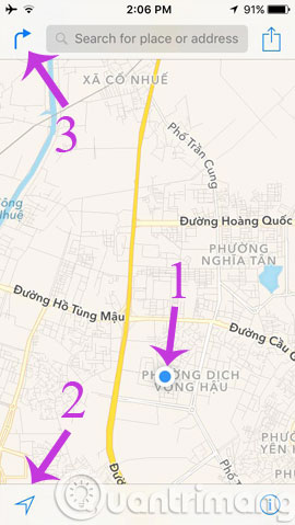
Step 1 : You open the Google Maps application and turn on the location on the device. You notice the arrow icon in the bottom left corner of the screen (number 2), the blue icon means that the GPS system is operating normally. Your current position will be a blue circle (number 1) in the middle of the screen. Then, click on the arrow to the right in the top left corner (number 3) to find the way.

Step 2 : In Directions , you will have 2 required fields that need to enter information. In the Start field, you can select Current Location to find the path from your current location or manually enter any address. End field for you to enter your destination. Similar to the Start field, this can be a specific or generic address, Google Maps will suggest a few places to choose from. Click the x icon if you want to delete the location you just entered and redo.

Step 3 : Immediately, the route from where you are to the destination will be highlighted on the map with the blue line. The first point is the green pin and the end of the red pin . Here is an overview of the road map on the city map, with information about travel time, total kilometers and the route that will pass through below the screen.
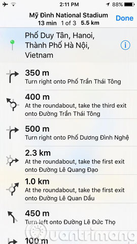
To see details about the route you can click on Detail in the bottom right corner of the screen. Other map options are provided in the i symbol in the bottom corner.
By default, Google Maps will provide information on routes by major means of transportation such as cars, taxis .

Step 4 : In the detailed route interface, Google will break down each street, starting from your current location, the streets will go through, turn left or turn right .

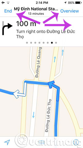
Step 5 : When you click on a specific route it will be illustrated more clearly and visually. To view all illustrations until the last place, drag from left to right. Click End to end the photo slideshow or Overview to return to the original overview map.

So with just a few simple steps, users of Google Maps on mobile can easily find their way on online maps. With Google Maps, you will find the best, fastest, and never lost path!
- Instructions for using Google Maps offline on Android
- Instructions to turn on positioning on iPhone
- Google Street View adds the "time machine" feature