
Admire the beautiful images of Earth taken by the Blue Ghost spacecraft
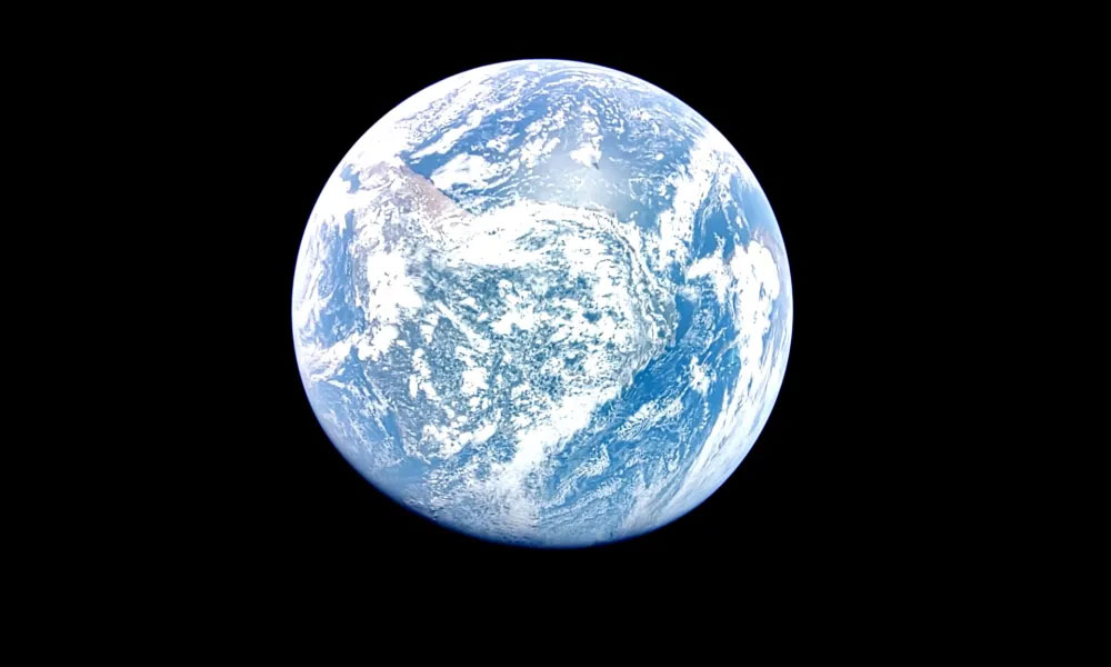
It's been a week since Firefly Aerospace's Blue Ghost mission began its journey to the Moon, carrying NASA's scientific instruments and aiming to perform the second commercial soft landing on the planet's surface.
Your browser doesn’t support HTML5 audio
It's been a week since Firefly Aerospace's Blue Ghost mission began its journey to the Moon, carrying NASA's scientific instruments and aiming to make the second commercial soft landing on the surface of the planet. During the journey, the spacecraft captured an impressive view: Earth in full view from a distance of nearly 6,500 kilometers.
The spacecraft will continue to orbit Earth for more than two weeks, gradually adjusting its trajectory until it performs a Trans Lunar Injection. This is a change in the spacecraft's thrust that will send it on a new trajectory toward the Moon. This maneuver is carefully timed to allow the spacecraft to fly precisely into the Moon's gravitational influence as it orbits Earth.
The spacecraft will then begin a four-day journey to the Moon on a trajectory called a lunar transit. Once on the Moon, it will perform a lunar orbit injection, then spend 16 days orbiting the Moon before attempting to land on its surface.
Although the Apollo missions have been sending humans to the Moon for more than 50 years, landing on the Moon remains a major challenge. The lunar surface is covered with rocks and boulders, and many areas have slopes and craters that make landing difficult. The first commercial landing, by Intuitive Machines last year, suffered a setback when the lander tilted when its legs caught on a cliff on the surface. The lander was still able to collect scientific data, but because of its tilt, it only collected a small amount of solar power and could only operate for a few days.
Firefly Aerospace hopes to make the landing smoother. It will use technology similar to that used to land rovers on Mars, called terrain relative navigation. In this, onboard computers will use images of the terrain below to select a suitable landing site.
You should read it
- The first spacecraft to fly by the Moon - Earth
- NASA's spacecraft soared to the asteroid that could destroy the Earth for specimens
- NASA wants to make spacecraft parts right on low Earth orbit
- The Earth used to be purple and 8 secrets of little surprise
- Admire the unique photograph of the Moon and Earth taken from Mars
- Cassini spacecraft, $ 3.26 billion machine 'bombarded' Saturn, ending its 20-year mission
- How much money does it take to get to Earth 2 and how long does it take?
- Download 1,000 beautiful wallpapers from Google Earth, completely free of charge
- 23 billion km away from Earth, how the spacecraft communicates with us
- Beautiful cracked walls of the most heterologous colors of the earth
- The mystery behind the Earth wallpaper on the first iPhone 13 years ago
- Interesting photos from Google Earth
Maybe you are interested
5 best SQL query optimization software to speed up MySQL Some basic points about the mechanism of attacking SQL Injection and DDoS These programming languages for the best mobile application development 13 important SQL statements Programmer needs to know Introduction to SQL Server Reporting Services To learn about SQL and databases, do not ignore these 23 online resources