11 mysterious places are blurred on Google Maps, what is being hidden?
There are some secret locations that are obscured or blacked out on Google Maps. Even if you zoom in all the way, you can't see it, so you can only curiously predict.
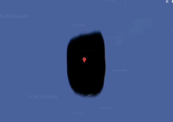
- Faroe Islands of the Kingdom of Denmark
- Commission on Atomic and Alternative Energy in France
- Area 51 in Nevada, USA
- San Blas Islands in the Caribbean
- Airport in North Korea
- Social Security Building of the Spanish Armed Forces
- Jeannette Island (Russia)
- Girona Province, Spain
- Munitiecomplex, Veenhuizen, Netherlands
- Patio de los Naranjos (Spain)
- Moruroa Island (Polynesia)
Faroe Islands of the Kingdom of Denmark

Although it is an interesting place to visit, half of the Faroe Islands of the Kingdom of Denmark are obscured on Google Maps. The reason is said to be because there is a military base located in this area. Therefore, only the middle part of the island with the capital Torshavn is visible on the map.
Commission on Atomic and Alternative Energy in France

In France, near the city of Avignon there is the Marcoule national nuclear research center, which is a branch of the Atomic Energy Commission. This location is also obscured on Google Maps for "research purposes".
Area 51 in Nevada, USA
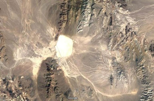
The world-famous Area 51 in Nevada, USA is also highlighted in white on Google Maps. Many rumors say that Area 51 is where research on alien life forms is conducted.
San Blas Islands in the Caribbean
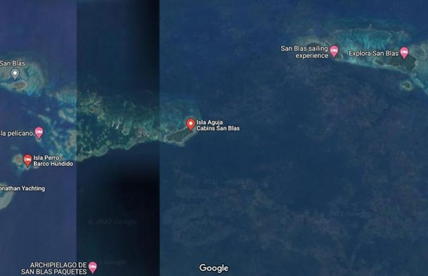
The San Blas Islands are located off the northern coast of the Isthmus of Panama and consist of 365 individual islands. On Google Maps, in the center of the archipelago there appears a thick black bar and everything to the right of it is obscured, while the left part is still clearly visible.
Airport in North Korea
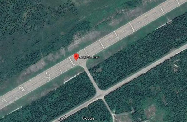
On Google Maps, the airport in Samjiyon Province, North Korea has been covered with a gray layer to hide important aviation objects.
Social Security Building of the Spanish Armed Forces
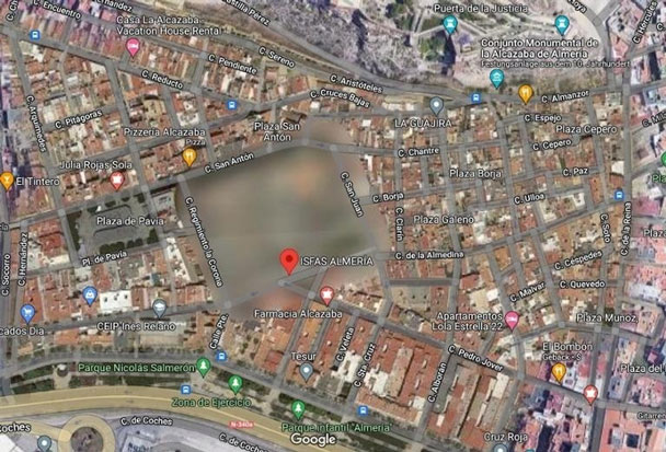
This building belongs to the Spanish armed forces, located in the city of Almeria in the Andalusia region. On Google Maps, the image of this building is so obscured that its shape cannot be seen.
Jeannette Island (Russia)
Jeannette Island is quite small, with a length of only about 2km, located in the Eastern Siberian Sea. In the center of the island there is a 350m high mountain peak. Nearly the entire island is constantly covered by ice.
Many people believe that this island is blacked out because this area is still in a sovereignty dispute between Russia and the United States.
Girona Province, Spain
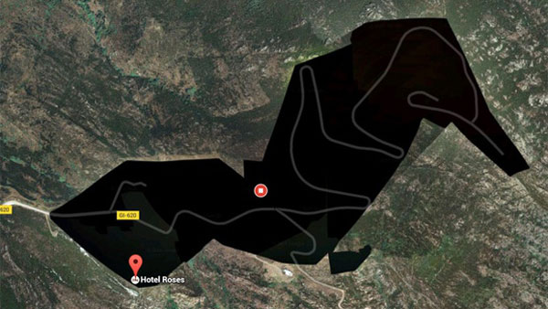
A black mass appeared in the northeast area of Girona, a province of Spain. There is nothing outstanding around this area. However, in that black space there is a hotel called Roses. Many rumors say that this hotel is a resort for the rich and famous. Therefore, there was an intervention to cover it up, avoiding the curious eyes of outsiders.
Munitiecomplex, Veenhuizen, Netherlands
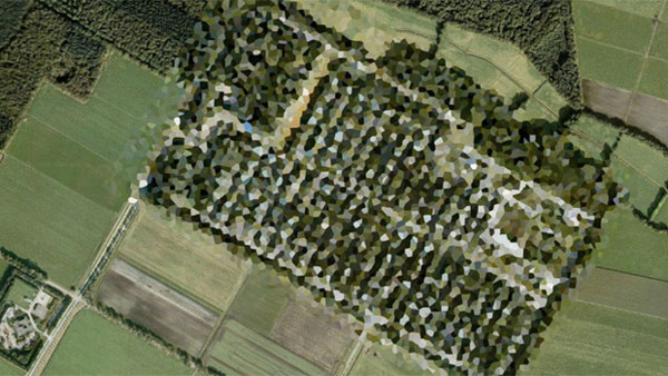
Viewed from above, this square piece of land looks like an oil painting. Many people believe that this area is actually an ammunition depot of the Dutch army and was hidden on the map by the government of the windmill country.
Patio de los Naranjos (Spain)
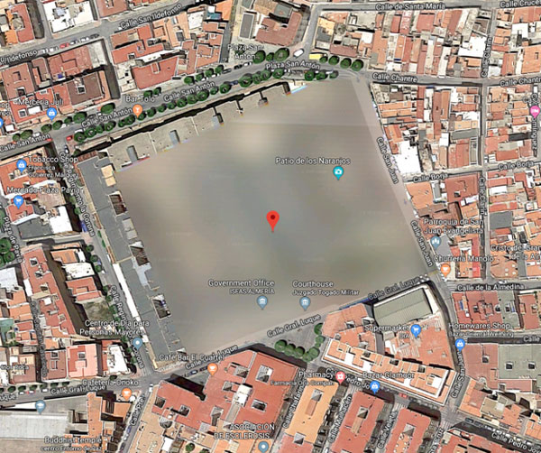
Google has completely blurred a fairly square campus called Patio de los Naranjos, located in the Spanish city of Almeria. This makes many people curious and trying to find out. According to many rumors, this area is related to projects being built for some important government purpose.
Moruroa Island (Polynesia)
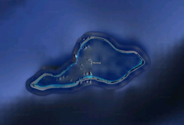
Moruroa is a coral island in the Polynesian national archipelago owned by the French Republic. Images of this island are never clearly displayed on Google Maps. Until now, no one knows the reason why, but many rumors suggest that it is related to the history of the island. Between 1966 and 1996, the island of Moruroa was the site of French nuclear testing, with a maximum total of 181 gruesome tests taking place.
- Extremely strange and mysterious places known to the world thanks to Google maps
- How to add places to Google Maps
- Mysterious and strange places appearing on Google Earth are astonishing people.
- 10 mysterious and strange places appear Google Earth that surprised people
- How to create and share favorite places on Google Maps
- Instructions for editing locations on Google Maps
- Tips for using Google Maps on Android
- How to bookmark and save places on Google Maps on your phone
- How to share maps, locations, and places on Google Maps with friends.
- Instructions for sharing exact location with hidden codes in Google Maps
- Close-up of the refrigerator manufacturing process
- Every beer bottle cap has 21 aliases, why?
- List of good fruits and vegetables for gout patients
- Differentiate between PVC and PE food wrap, which is safe and best
- Vietlott Lottery: Play rules and prize structure
- Olm salamander, strange animals do not budge for 7 years, eat once every 10 years
- The set portrays the life of poor workers in Hong Kong in the 1990s
- Does using induction hob affect health?
- Mango trees are 1m high with 800 fruits in Japan
- Fish pop out of breathtaking fruit juice
 Garena Free Fire - Free Fire OB51 Version
 How to Hide Dynamic Island on iPhone
 How to bring Dynamic Island to Android phone
 6 Apps That Make Your iPhone's Dynamic Island Useful
 Tips for using Dynamic Island on Android smartphones
 4 walking paths across the sea in Vietnam