How to measure height with a smartphone
Combined with an atmospheric pressure sensor and data connection (if available), the smartphone can help you read surprisingly accurate heights.
Table of Contents
Everyone sometimes has to move to different height positions and some people want to measure that vertical movement. That is why there are so many altimeter applications. You can use your phone location to perform 2D street-level navigation all the time, but similar satellites can also help you find altitude from the surface of the earth (not the altitude). with sea level). Combined with an atmospheric pressure sensor and data connection (if available), the smartphone can help you read surprisingly accurate heights.
How does the phone measure altitude above sea level?

A lot of the elevation changes above sea level have been mapped by geospatial survey projects, so most pairs of latitude longitude coordinates can be used for elevation lookups. corresponding. However, this usually requires data and is only accurate for you personally, if you stand on the ground.
How does the phone measure altitude from the surface of the earth?
The most important tool for measuring altitude from the earth's surface in your arsenal is the GNSS / GPS receiver. If your phone can find at least 4 satellites, with one satellite directly above your head, you can usually read the height from the earth's surface precisely within 10 to 20 meters (35 to 70 feet). While good satellite reception is not always guaranteed, and calculating altitude from the earth's surface based on GPS works in most cases, it can still be quite buggy. .

That is why many modern phones are also equipped with atmospheric pressure sensors (manometers). Because gravity pulls everything down to the earth, including the atmosphere, the pressure will drop as your altitude increases from the surface of the earth. Measuring this change helps the phone find the height to rise or fall.
However, changing weather can also affect atmospheric pressure, so most altitude applications from the earth's surface will try to get the latest pressure data from the gas station. nearby statues. This gives the application something to compare the pressure changes. Altitude measurements from the earth's surface based on a manometer can still work without a data connection, but you may need to calibrate it manually.
There are tons of apps that measure the altitude of the earth's surface and altitude for iPhones, as well as Android, and to be honest, their accuracy isn't much different. The best apps, though, like the ones below, go beyond simple measurements to provide other environmental data and monitoring features.
5 altimeter applications for phones
1. Altimeter & Altitude Widget
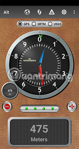
This app from DS Software uses location, barometer and geospatial survey data to help you get accurate elevation data from the earth's surface and altitude above sea level, along with it's a series of maps and features that allow you to record, as well as graph your altitude trend graph. Being able to easily switch between altitude (SRTM and USGS settings) and altitude from the surface of the earth (GPS and Bar) is a great feature, as comparing these two numbers has can help you understand the accuracy of the altitude from the earth's surface. If you have a manometer, the app also offers a range of calibration options, which allow you to get data from the nearest airport or manual settings. The level of detail and diversity of altitude / elevation settings from the earth's surface and tracking features make this an excellent option.
2. Altimeter GPS - Hike & Trek
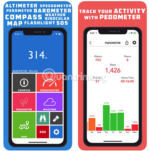
This iOS app comes with a standard altimeter, barometer and compass, plus a pedometer and cruise tracking so you can visualize your distance and altitude changes. There is an SOS feature that can even automatically send someone your location in an emergency. However, it is the trip tracking feature that makes this app different, as there are many altimeter apps on iOS that don't come with this feature.
3. Altimeter Ler
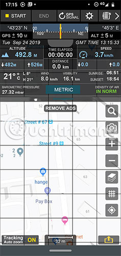
This app design makes you feel like you are in an airplane cockpit. Altimeter Ler gives you complete information on location and environmental conditions, along with many useful maps and tracking features. The application can calculate the height from the earth's surface based on both GPS data and manometer, even let you know the error of GPS data being received. Altimeter Ler doesn't have visual tools to track elevation changes from the earth's surface or elevation data, but it comes complete with other features to compensate. for those shortcomings.
4. My Altitude
- Download My Altitude for Android
- Download My Altitude for iPhone

This app has some issues with Android, but is probably the best altitude-earth app for iPhones. You get everything you need here: Altitude from the surface of the earth, coordinates, atmospheric pressure, boiling point of water, weather - even NOAA data you can download to use Offline application. My Altitude doesn't come with any tracking or graphing features, but it does have a tool that allows you to take photos with altitude from the earth's surface, time and coordinates attached.
5. Altimeter (by EXA)
The EXA altimeter for Android doesn't provide a lot of additional data, but its interface is easy to read and Altimeter's tracking feature could actually be one of the best options on this list. , thanks to a nicely presented elevation change chart. Altimeter comes with lots of ads (you can remove these ads by paying) and the app itself works very well.
Should you use a true altimeter?
If none of the above options meets your needs, you can keep an eye on a true altimeter, instead of using a phone. The good news is that this may not be necessary, if the phone has a GNSS chipset and a manometer, as tests have shown that smartphones and altometers have similar accuracy.
Wish you find yourself a suitable choice!
Was this article helpful?
Your feedback helps us improve.
Related Articles
 How to Measure TV Size8 minutes read
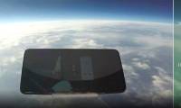 This is a durable smartphone, falling from a height of 31km above the ground but only slightly damaged on the screen glass.2 minutes read
 Simple calculation to know how high your child will be3 minutes read
 How to measure the alcohol content with a smartphone3 minutes read
 Height and width in CSS2 minutes read
 Please download Google's Measure app, which supports all Android-compatible ARCore smartphones2 minutes read
Reader Comments 0
Sign in with email or Google to join the discussion.