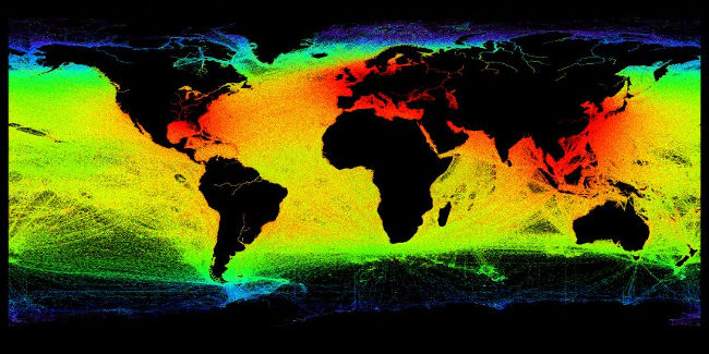
Satellite creates a detailed picture of maritime operations
The European Space Agency (ESA) has helped coastal authorities track more than 70% of ships and receive more detailed ship positions three times via satellites than before.
The European Space Agency (ESA) has helped coastal authorities track more than 70% of ships and receive more detailed ship positions three times via satellites than ever before.
Large cargo ships and passenger ships must carry Automatic Identification System. It transfers route, speed, as well as positioning and location information to other ships and seaside stations. Developed to prevent collisions, the system now also tracks vessels to help prevent contamination, helping in the transport of dangerous goods and promoting regular maritime monitoring.
The Norwegian Coast Authority is using information to manage the nation's coast and waters for safety, emergency and sea transport planning.
The advanced receivers developed by Kongsberg Seatex in Norway with the support of the European Space Agency ESA, were integrated on two NorSat satellites last year. During the first four months of operation, the receiver significantly improved detection of identification signals.
The satellites help increase visibility for important positioning information from a height of 74km above sea level to 2500km from low orbit, meaning more ships can be seen at the same time.
In areas with heavy maritime traffic, the number of signals sent by the ships may be too high, causing the signal to be stuck in the satellite receiver. The solution is that the new signals are easily collected by satellites and have less interference from other train signals.
Ivar Spydevold, CEO Statsat added: "The total number of signals from NorSat receivers usually reaches 2.5 million signals a day. This is nearly three times the number of previous receivers on AISSat- 1 and 2, with a total of about 900,000 signals a day " .
See more:
- The ocean is losing "breath"
- Coral reefs are severely bleached without the impact of El Nino
- Unmanned aircraft help scientists monitor endangered sea turtles
Was this article helpful?
Your feedback helps us improve.
Related Articles
 Picture in Picture on iPhone: How to activate and use Picture in Picture (PIP)5 minutes read
 NASA satellite views of Chernobyl Exclusion Zone wildfires paint a worrisome picture2 minutes read
 Manage servers and databases with detailed utilities in SQL Operations Studio (preview)3 minutes read
 How to check the balance of Maritime Bank account5 minutes read
 This is the most detailed map of the seafloor ever made.1 minutes read
 How to turn on Picture in Picture on Edge is extremely simple4 minutes read
Reader Comments 0
Sign in with email or Google to join the discussion.