Explaining the mysterious gravity loss phenomenon in some places in Canada?
Some places on Canadian territory, especially the Hudson Bay area, have a mysterious loss of gravity . This phenomenon was discovered in the 60s of the last century that made scientists headache over the years.
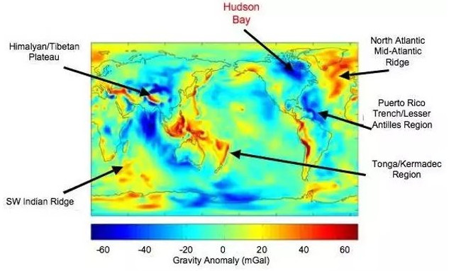
In the 1960s, when mapping global gravity, stories of the Hudson Bay and the surrounding area had unusual gravity. In other words, gravity in these areas is more attractive than in other parts of the world.
We all know, gravity is directly proportional to the mass. Studies have shown that Earth's mass is not uniformly distributed and may change over time.
Scientists can map gravity fields from the universe and find small changes each year

Map of gravity distribution in the world.
Several years ago, scientists from the Harvard-Smithsonian Center for Astrophysics and the University of Toronto (Canada) measured planetary gravity with a sensor attached to NASA's GRACE satellite.
Data from GRACE allows scientists to create topographic maps depicting the Hudson Bay during the last ice age, when the bay is still covered by Laurentide ice .
Laurentide ice is 3.2 km thick and 2 places in Hudson Ice Bay is 3.7 km thick. It was a very heavy piece of ice on the Earth. Over 10,000 years, the Laurentide ice sheet has melted and disappeared only to leave a dent on the green planet. The ice melts slowly so the crust doesn't push back. According to experts, gravity has lost half.
According to geophysicist Mark Tamisiea of Proudman Oceanographic Laboratory in Liverpool, the clear indication that gravity at Hudson Bay is increasing every year.
The Laurentide iceberg hypothesis only explains 25% to 45% of gravity variation around Hudson Bay.

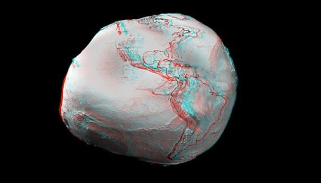
The 3D graph shows the larger the gravity bulge.
Eliminating the " recovery effect ", scientists have determined that 55% to 75% of gravity changes are due to convection occurring in the earth's crust.
The coating is a layer of molten rock called magma and exists at a depth (100 to 200 km) below the surface of the Earth. Magma is very hot and moves continuously, rising and falling, and creating convection. Convection pulls down the continental plates of the earth, reducing the mass in that area and reducing gravity.
The Hudson Bay of Canada is also considered a low-gravity place for a long time. Scientists estimate that the Earth takes about 5,000 years to recover more than 0.2 km of rock to return to its original position. We can see the recovery effect.
Although the sea level is rising worldwide, the sea level at the coast of Hudson Bay is reduced because the rock continues to recover due to the weight of the Laurentide ice sheet.
GRACE satellites are very sophisticated machines, orbiting around 500 km above the earth. The satellites can measure distances to micron sizes, so they can detect gravity variations even if only very small. When satellites lead the way over Hudson Bay, weak gravity causes the satellite to travel further than the earth and with satellites accompany it. The change in this distance is detected by the satellites and used to calculate the change in gravity. Any changes recorded are used to create attractive field maps.
You should read it
- ★ Decode the ball mystery itself 'climb the slope' at the 'non-gravity' hill
- ★ Experimental science proves that gravity is still effective at 50 micrometers
- ★ Use the Sun's gravity to transmit interstellar signals
- ★ Appears more clues proving the existence of the mysterious 9th Planet in the Solar system
- ★ Why can this man jump from 7,600 meters to the ground without parachutes