Announced the first comprehensive geological map of the Moon
The United States Geological Survey (USGS) has just released the first detailed mapping system for the geological characteristics of the Moon.
The United States Geological Survey (USGS) has just released the first detailed mapping system for the geological characteristics of the Moon, helping to explain the history of geological formation and tectonics in about 4 years. , 5 billion years of our nearest neighbor in the universe.
The map, called "Unified Geologic Map of the Moon," was analyzed and agreed upon by USGS scientists themselves over the years with thousands of studies, large and small, with the help of NASA and the Institute. American Moon Research, will serve as the final design of lunar surface geology to serve the study as well as conduct future human discoveries. It is also considered an invaluable achievement for the international scientific community, educators and the whole of humanity.
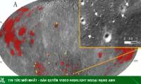
In particular, Unified Geologic Map of the Moon, also available as a digital version, is now available online, showing the moon's geological features in amazing detail (1: 5,000,000).
'The moon has always been something that fascinates people for thousands of years. The introduction of the lunar geological map will greatly contribute to astronomy, education and space exploration. A lot of help to aerospace agencies like NASA in planning important missions for future exploration, '' said Jim Reilly, director of the USGS and former NASA astronaut. .
 "Unified Geologic Map of the Moon"
To create this intricate digital map, the scientists used information from six maps of the Apollo lunar regions, along with updates from dozens of lunar exploration missions over the years. by. In parallel with the merging of new and old data, USGS researchers have also developed a unified description system of stratigraphy - the rock layers of the moon, helping to solve existing problems in Previous mapping systems, including the regulation of geological types and dating, were sometimes inconsistent.
'This map is the culmination of a decades-long project. It provides an important source of information for lunar research by connecting and consolidating knowledge learned over the years. '
Altitude data for the moon's equatorial region comes from observations collected by the Terrain Camera system in JAXA's SELENE (Selenological and Engineering Explorer) mission conducted by the Japan Aerospace Exploration Agency. and recently completed. The topography of the North and South Moon was analyzed from NASA's long-standing Lunar Orbiter Laser Altimeter system.
Was this article helpful?
Your feedback helps us improve.
Related Articles
 Earth's Moon Revived Recently?4 minutes read
 NASA: 'Saturn's Titan moon will be our next stop'5 minutes read
 Full Moon facts - Full moon you may not know yet13 minutes read
 Discover incredible facts about the Moon3 minutes read
 This is why we always see the Moon always following us2 minutes read
 What is a corn moon?4 minutes read
Reader Comments 0
Sign in with email or Google to join the discussion.